📍 Quick Facts & Useful Info
🧭 Open in MapsLocation📍 Sardinia
Accommodations nearby🏡 10 Mare In holiday resorts starting from 14.5 km
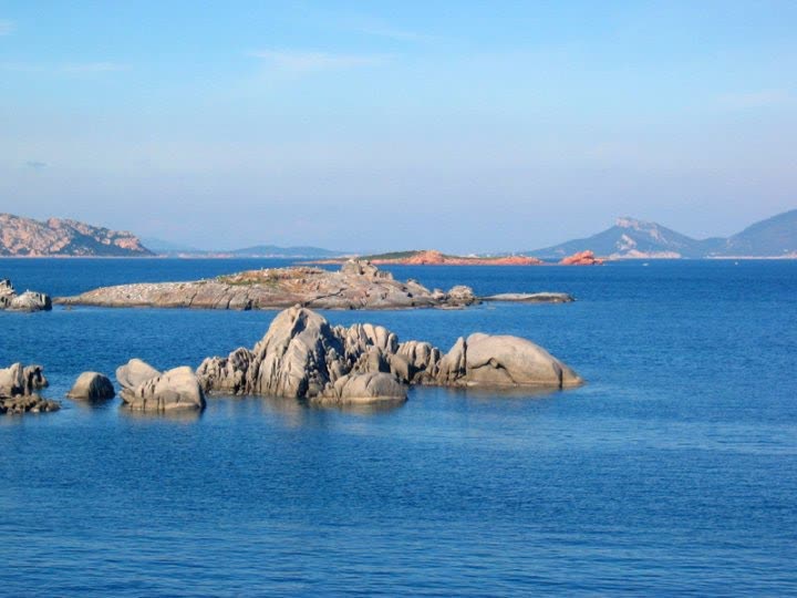
Asinara Island covers an area of approximately 52 square kilometers at the northwestern tip of Sardinia, opposite the Capo Falcone headland (Stintino), and forms the western boundary of the Gulf of Asinara. Administratively part of the municipality of Porto Torres, the island has been protected since 1997 by the establishment of the Asinara National Park and the “Isola dell’Asinara” Marine Protected Area, measures that fully preserve its terrestrial and marine ecosystems. The terrain, which is predominantly mountainous and hilly (reaching a peak of 408 meters at Punta della Scomunica), features high, sheer western cliffs overlooking the open sea and a more varied eastern slope, characterized by granite inlets and sandy coves framed by Mediterranean scrub.
The island's main beaches are subject to different protection regulations established by the Park Authority:
• Cala Sabina: Located in the northeastern sector at the base of the promontory of the same name, a short distance from the village of Cala d'Oliva, it is one of the most beautiful and famous beaches where public swimming is permitted. It is characterized by very fine white sand with subtle pinkish hues, a shallow seabed, and crystal-clear turquoise waters.
• Cala d'Arena: Located at the northern tip of the island, near Punta Scorno, it falls within Zone A of the integral reserve. Access to the beach, transit, anchoring, and swimming are strictly prohibited in order to preserve the delicate dune ecosystem of pure white sand with pinkish hues and to protect the reproduction of protected wildlife.
• Cala Sant'Andrea: Located along the central-eastern coast, it is a sandy crescent about 350 meters long, nestled between pink granite cliffs. It, too, is part of Zone A of the strict reserve and is closed to the public to protect one of the most important nesting sites for the Corsican gull and other seabirds.
For snorkeling and exploring the seabed (in permitted areas and with authorized centers), Cala dei Ponzoli, Punta Barbarossa—known for its underwater archaeological sites featuring Roman-era amphorae—and Cala Trabuccato, dominated by the Aragonese tower of the same name and characterized by Posidonia meadows that are home to specimens of Pinna nobilis (the sea fan mussel, the largest bivalve mollusk in the Mediterranean). The island is also home to the Marine Animal Rescue Center (C.R.A.M.A.), which is dedicated to the care and rehabilitation of loggerhead sea turtles (Caretta caretta).
ℹ️ Services and Park Tour:
There are no fully equipped beach resorts on the island, and services are concentrated at the three main landing spots (Fornelli in the south, Cala Reale in the center, and the village of Cala d’Oliva in the north), where you’ll find information centers, bars and restaurants, a hostel, and museum exhibits dedicated to the history and nature of the park. For those who want to spend a few hours at the beach in Cala Sabina or at other swimming coves, it's a good idea to bring a supply of water. The landing and movement of private vehicles are prohibited: Visits to the island are conducted via guided tours in 4x4 off-road vehicles, a rubber-tired train, the park’s electric minibus, or independently by renting bicycles (including e-bikes), authorized electric cars, or by hiking or horseback riding along the trails. Along the coastline, there are also boats offering sailing excursions, rubber dinghy trips, fishing tours, and diving excursions with accredited diving centers.
🚗 How to get there:
Asinara Island can be reached only by sea. From the port of Porto Torres, there is a year-round public ferry service (for passengers and bicycles only) that docks at the Cala Reale pier after a voyage of about 75 minutes. From the port of Stintino (Marina di Stintino and the Tanca Manna pier), passenger motorboats, rubber-hulled boats, and authorized sailboats that reach the southern pier at Fornelli in about 20 minutes or continue on to Cala Reale and Cala d'Oliva.
💡 Fun fact:
1. The white donkeys of Asinara and the origin of the name “Sinuaria”: The island’s unmistakable symbol is the white donkey of Asinara, a rare endemic population affected by a form of incomplete albinism (characterized by a snow-white coat, pinkish skin, and cerulean-blue eyes) that roams freely in the wild among the pastures and trails of the park. Interestingly, it wasn't the island that took its name from donkeys, but the other way around: the ancient Romans called the island "Sinuaria" because of the extremely winding and jagged shape of its coastline, a place name that evolved over the centuries into "Asinara."
2. A Century of Isolation: From the Lazzaretto to the Superprison, and On to Falcone and Borsellino: Asinara’s exceptional state of environmental preservation is linked to its contemporary history. In 1885, the Kingdom of Italy expropriated the island (whose inhabitants—shepherds of Ligurian origin and fishermen—founded the town of Stintino on the opposite coast) to establish a Sanitary Quarantine Station (at Cala Reale) and an Agricultural Penal Colony there. During World War I, the island housed tens of thousands of Austro-Hungarian prisoners of war, and in the 1970s it became a maximum-security prison, which remained in operation until its permanent closure in 1997. In the summer of 1985, for maximum security, Judges Giovanni Falcone and Paolo Borsellino spent several weeks with their families at the guesthouse in Cala d'Oliva to draft the judgment in the Maxi-Trial against the Cosa Nostra.
3. The Aragonese towers, the Punta Scorno Lighthouse, and the Camaldolese Monastery: Three historic watchtowers built in the 17th century during Spanish rule stand along the island’s coastline (the Cala d’Arena Tower to the north, the Cala d’Oliva Tower and the Cala Trabuccato Tower to the east) to defend the coastline from Barbary pirate raids, as well as the imposing Punta Scorno Lighthouse, which has been in operation since 1859 at the northern tip to guide sailors through the Strait of Bonifacio. Near Cala Sant'Andrea, you can also see the ruins of the ancient medieval monastic settlement of Sant'Andrea, founded by Camaldolese monks around the 12th–13th centuries.
📍 Location Map
Geographic Location
Do you want to go on holiday near this wonderful beach? Fill out the form to receive our accommodation proposals.
📬 Request a quote
Enter your contact details to be reached back with no obligation.
🏷️
Best Price Guaranteedlower than other portals
🚢
Ferry discounts up to 30%included in your package
⚡
Free quote in 2 hourswith no obligation
🏡 Where to stay
Recommended Holiday Resorts

Stintino - Roccaruja Resort
📍about 14.5 km from here

Stintino, Cala Lupo
📍about 14.9 km from here

Sporting Resort - Stintino
📍about 14.9 km from here

Castelsardo Lido Residence
📍about 36.9 km from here

Costa Paradiso
📍about 54.5 km from here

Aglientu Gallura Beach Village
📍about 69.7 km from here

Lu Pultiddolu Villa, Santa Teresa Gallura
📍about 73.9 km from here

Rena Maiore Villas and Holiday Homes
📍about 74.2 km from here

Baia Santa Reparata Shardana
📍about 74.3 km from here

Baia Santa Reparata Holiday Homes
📍about 74.3 km from here